Beyond Spraying: Non-Spraying Uses Of Drone In Modern Ranching
When most people think of drones on the farm, images of crop spraying and chemical application typically come to mind. But on today’s modern ranches, drones are quietly revolutionizing operations in ways that have nothing to do with spraying. From low-stress cattle mustering and livestock monitoring to fence line inspection and water source management, drones have become an indispensable eye in the sky.
As the saying goes, running a ranch has always been about knowing your land, your animals, and trusting your instincts. Yet even the most experienced ranchers miss subtle changes that could turn into bigger problems later. Today, drones are giving ranchers a new perspective—a way to see the whole picture from above, spot issues early, and make smarter choices without replacing the hard-earned experience that comes from years on the land.
Let’s explore the most impactful non-spraying uses of drones in modern ranching and how these innovations are saving time, lowering stress on animals, and protecting the bottom line.
Smarter Cattle Herding & Mustering: Replacing Helicopters and Horses
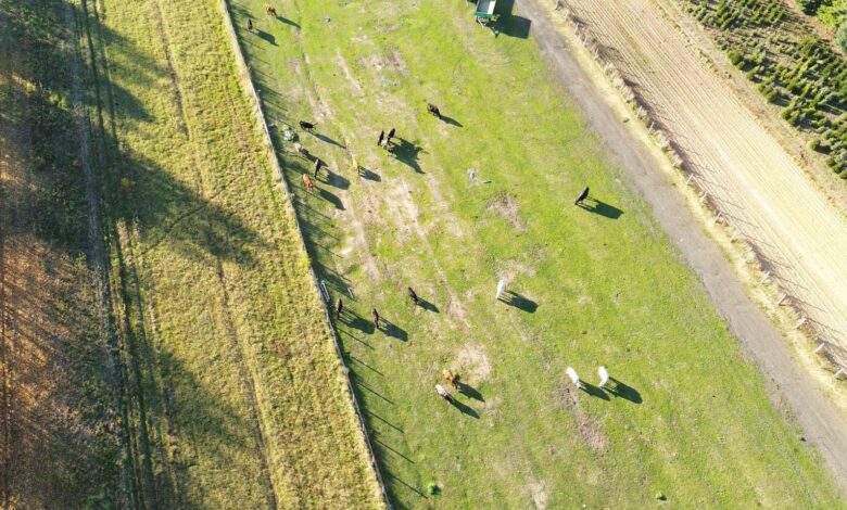
Traditional cattle herding requires significant manpower, fuel, horses, ATVs, and time. In rugged terrain or on large properties, locating a herd can take hours. Drones have changed this dramatically.
SkyKelpie: Mustering Cows from 300 KM Away
Australian stockman Luke Chaplain—founder of SkyKelpie—made headlines in 2025 with a world‑first demonstration: mustering cattle on a farm 300 kilometers away from a remote operations center set up inside a convention center. No horses, no motorbikes, no helicopters—just precision, low‑stress stock handling via drone. SkyKelpie also secured regulatory approval for a mobile remote operations center from Australia’s Civil Aviation Safety Authority (CASA), paving the way for remote drone mustering to become a commercial reality.
The technology works on a simple principle: herding animals have a flight zone. Using the drone to apply gentle pressure, cattle naturally move away, just as they would when approached by a helicopter. The pilot keeps them light and responsive—releasing pressure when movement starts. This delicate balance is the art of aerial stockmanship.
Night Mustering with Thermal Imaging: Why It’s Changing the Industry
Thermal imaging has opened up an entirely new window of opportunity. Central Queensland beef producer Will Wilson has been mustering cattle for over a decade, but he now does most of his work at night—because cattle move better in the dark, and the heat of the day is avoided entirely.
Wilson noted that ranchers should persist with the drone. If the pilot lets even one animal win, the whole mob can start ignoring the drone. With that rule in mind, Wilson found that night operations work exceptionally well: once the cattle are in a mob, they can be steered almost anywhere in the dark because they gain confidence in numbers.
Australian Country Choice (ACC), one of Australia’s largest beef enterprises, used night‑time thermal‑imaging drones on their 122,000‑hectare Moray Downs property to flush out wily bulls and cows hiding in dense brigalow regrowth. Across four nights, drones detected animals by their body heat from 120 meters up, completing the muster of 11,500 weaners, cows, and bulls.
Why at night?
- Beats the heat: It’s easier on animals and staff
- Animals move better: Cattle are more cooperative in cooler conditions
- Thermal advantage: Animal body heat is clearly visible against the cool landscape
- Early start: Drones work cattle in the dark so ground crews can pick them up at first light
ACC’s property manager summed it up: “The drone can muster the cattle in the dark, so that the horses can pick them up at daylight and get an earlier start. It beats the heat and makes it easier on animals and staff all round.”
The Economics of Drone Mustering
Heavy reliance on helicopters comes at a steep price. A single helicopter run can cost upwards of $1,000 per hour—yet drones offer a safer, more affordable alternative, able to scan vast areas at a fraction of the cost without the fuel, crew, or risk.
An economic analysis indicated that drone mustering can be a cost‑effective alternative with potential savings in operational costs and time.
This aligns with reports from Australian stations, where drones saved up to 20% in mustering costs by simply pre‑locating mobs before the ground crew heads out.
The introduction of more affordable drone models, such as the DJI Mavic 3 Enterprise Thermal, has increased the return on investment, making drone technology accessible to a broader range of producers.
Improving Herd Health: Precision Diagnostics & Birth Monitoring
Thermal Imaging for Early Disease Detection
Drones equipped with thermal cameras allow ranchers to detect animals with elevated body temperatures—a common early sign of illness or infection. By flying over the herd, drones can quickly identify animals showing signs of fever or distress from above, all without disturbing the herd.
The University of Veterinary Medicine Budapest recently acquired a DJI MAVIC 3T drone equipped with thermal and multispectral cameras. Their research demonstrates that drones can identify sick or injured animals with up to 90% accuracy. Moreover, the technology helps monitor hygiene and epidemic control conditions in food production facilities, contributing to safer food chains.
A K‑State research project is establishing aerial thermal imaging as a valuable tool for cattle producers and feedlot managers. By using drone technology, producers can better understand where cattle are spending their time, allocate labor resources more efficiently, and detect issues early. “Labor is one of the highest costs for cattle producers and feedlot operators,” said researcher Haley Larson. “Our research looks to provide an additional eye‑in‑the‑sky way of determining where to use those resources best.”
Calving Season Monitoring
Drones have become invaluable during calving seasons. With a quick flyover, ranchers can check for newborns, identify cows that are actively calving or struggling, and find animals that have become isolated from the herd. Research from Utah State University showed that drones effectively help locate cattle in hard‑to‑reach areas, especially during round‑up season in mountain ranges. Drones can be deployed to focus horseback rider efforts, reducing injury risk to both horse and rider in rough terrain.
Rangeland & Pasture Management: Data‑Driven Grazing Decisions
Drones are transforming how ranchers manage grazing rotations and pasture health.
Vegetation Mapping & Forage Assessment (NDVI)
Equipped with multispectral cameras and aerial mapping software, drones generate detailed topographic maps and vegetation indices. These tools clearly show:
- How dense the forage is in different areas
- Spots that are overgrazed or underused
- Soil compaction patterns
- Areas at risk of erosion
Drone‑based imagery can accurately capture spatial variations in grazing behavior and vegetation conditions. Instead of rotating cattle based on visual estimates alone, ranchers now make decisions based on precise, reliable data—supporting rotational grazing systems that protect root structures, improve regrowth rates, and extend pasture longevity. Over time, archived drone imagery allows ranchers to compare seasonal performance year after year, turning imagery into a powerful management tool.
LiDAR for Individual Cattle Growth Tracking
Researchers from the University of Canterbury have demonstrated that UAV‑based LiDAR (Light Detection and Ranging) systems can monitor the growth of individual beef cattle on a large scale. By scanning 96 semi‑free‑range beef cattle, the system generates point clouds for each animal, extracting body measurements such as height, width, and length. These measurements help evaluate live body weight—without the stress of yarding or handling.
Capturing 3D data from the top‑down perspective is particularly effective: key features relevant to cattle growth monitoring are distributed along the back of the animal. Aerial LiDAR enables non‑intrusive, remote sensing without direct animal contact, representing a major breakthrough in precision livestock farming.
Ranch Infrastructure & Security: Cutting Man‑Hours on Routine Tasks
Thousands of miles of fences, water pipelines, troughs, and remote entry points—ranches are massive operations where infrastructure failures can cost thousands before anyone notices.
Fence Line Inspection
Drones can cover miles of perimeter fencing quickly and efficiently. They can identify breaks, damage, or areas needing maintenance without requiring ground crews to traverse challenging terrain. With live video feeds, a rancher can patrol fence lines in minutes rather than days, detecting unauthorized vehicles, monitoring entry points, and identifying strays near fence lines.
Water Source Monitoring (Troughs, Pipelines, Tanks)
Ranchers who previously spent hours on maintenance rounds now launch a drone to check water levels, confirm pump operation, and spot leaks. Running a ranch has 20+ miles of water lines, water troughs, stock ponds, and tanks that typically require many man‑hours to manage. A drone quickly monitors the entire system from the air, flagging equipment failures or contamination issues instantly.
Wide‑open landscapes mean that a single unnoticed leak can empty a trough, leaving cattle without water for days. Drones solve that problem before it becomes a crisis.
Feral Animal & Predator Management
Feral pigs, wild dogs, foxes, and other predators cause massive economic damage to livestock operations each year. The same thermal cameras used for night mustering are equally effective for locating feral animals. Feral pigs can be detected during the night and in low‑light conditions without worrying about battery life. The RGB camera captures high‑definition images for species identification and population tracking.
OSPRI in New Zealand has also tried using thermal drones to identify and track possums across vast, difficult countries. Once an animal is spotted, the drone captures location data for population mapping, allowing targeted control measures.
Legal Considerations & Getting Started
Before integrating a drone into your ranching operation, it is critical to understand local regulations. In the United States, for example:
- Recreational flight: The Recreational UAS Safety Test (TRUST) is required for hobbyists.
- Commercial flight: Pilots must earn an FAA Part 107 Remote Pilot Certificate.
- Registration: Drones weighing 0.55 to 55 pounds generally need to be registered with the FAA at $5 per drone, valid for three years.
- Visual Line of Sight: Drones must remain within the operator’s (or an observer’s) sight at all times and must yield to other aircraft.
Even flying your drone over your pasture to check a water tank is considered a commercial operation on most ranches, so obtaining the proper license is strongly recommended.
Why Jinghong Drone Is Your Partner in Modern Ranching
At Jinghong Drone , we deliver agricultural drone solutions tailored to the unique needs of livestock producers. Our systems are engineered for the demands of large‑scale ranching—durable airframes, extended flight times, and support for both visual and thermal sensors.
We focus on solving real challenges:
- Mounting optional speakers to move cattle remotely
- Streaming high‑definition video to your tablet from miles away
- Managing flight plans to cover thousands of acres systematically
- Integrating with herd management software to make data usable
Ready to put an eye in the sky to work for you? Explore our full range of agricultural drones at jinghong drone and see how non‑spraying drone solutions can transform your operation.
Frequently Asked Questions (FAQs)
Q: Can I use the same drone for both spraying crops and mustering cattle?
Yes, many agricultural drones are capable of both functions. However, the ideal configuration differs—spraying requires specific tank and nozzle setups, while mustering typically needs a high‑zoom visual camera or thermal sensor. Jinghong Drone offers modular systems that can be adapted for both tasks.
Q: How much money can I actually save by using drones for mustering?
Savings vary by operation size, but producers report significant reductions. Helicopter mustering can cost $500–$1,000 per hour, while drone operating costs are dramatically lower. Additionally, by pre‑locating herds before sending out ground crews, many stations save up to 20% on mustering costs. Fuel, labor, and vehicle wear costs on daily checks also drop noticeably.
Q: Can I fly a drone at night?
Yes—but special equipment and regulations apply. Night operations require thermal imaging cameras and, in most countries, a specific remote pilot certification and lighting on the drone to maintain visual line of sight. With proper authorization, night mustering is one of the most effective drone applications available.
Q: Do drones stress out cattle?
When flown correctly, drones produce less stress than helicopters, motorbikes, or dogs. They apply gentle pressure from above, rather than chasing or chasing aggressively. Research from Utah State University and on‑farm experience both confirm that low‑stress drone herding techniques can actually improve animal welfare by eliminating the loud noise and aggressive chasing common with traditional methods.
Q: What is the daily battery life expectation for mustering?
Most commercial agricultural drones fly 20–30 minutes per battery under normal loads. Serious ranching operations carry 8–10 batteries per drone, and some use generator‑powered battery charging stations in remote areas to keep the system flying all day. Hard‑working stations often run multiple drones in rotation to cover vast territory.
Q: Do drones work in heavy wind or rain?
Consumer‑grade drones are generally not weather‑resistant, but professional agricultural drones are built to IP67 standards, meaning they are protected against dust, water, and corrosion. However, even rugged drones have operational limits—most manufacturers recommend grounding in winds above 10–12 m/s and lightning.
Q: Can drones replace the need for livestock dogs or horses entirely?
Drones are a powerful tool, but most ranchers view them as a complement to horses and dogs, not a complete replacement. The combination of a thermal drone for locating animals and a well‑trained ground crew for handling is proving to be the most effective and humane solution.
Q: How do I train my team to use a drone on the ranch?
Professional drone manufacturers and agricultural extension programs offer structured training—covering flight basics, maintenance, emergency procedures, and herd‑handling tactics. Most producers also develop their own herd‑specific techniques based on experience. Jinghong Drone provides comprehensive training and support for new operators.
Conclusion
Drones on modern ranches are no longer experimental—they are an essential tool. By mustering at night with thermal cameras, you cut costs, save time, and drastically reduce animal stress. By checking water and fences from the air, you catch problems early and avoid devastating failures. By tracking cattle health from above, you intervene before sickness spreads. And by using vegetation mapping, AI alerts, and LiDAR weight estimation, you make data‑driven, profitable decisions for the long term.
The era of relying solely on horses, helicopters, and manual checks is fading. The most successful ranches will be those that combine old wisdom with new technology—saving time, reducing stress, and creating a more sustainable, productive future.